


Concentric rocky rings in the Sahara look like an impact crater — but astronaut photos reveal a far stranger origin
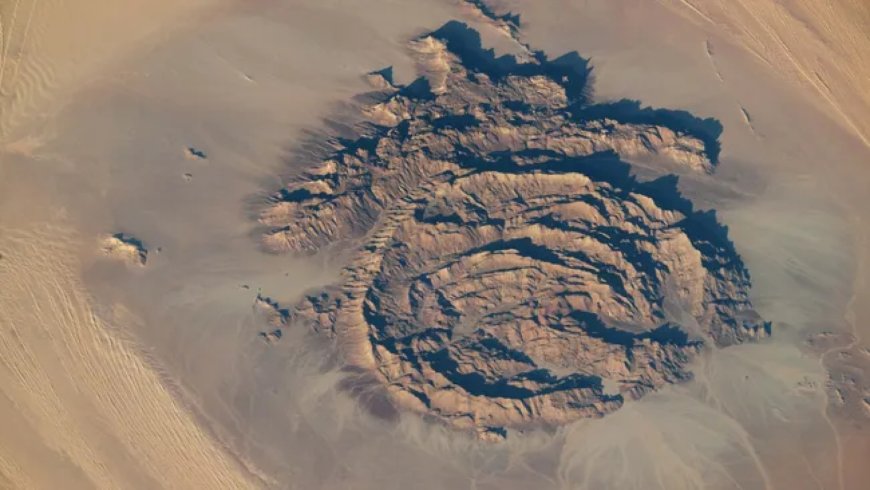
From the International Space Station, it looks unmistakably like a scar left by a meteorite: a series of concentric rocky rings, their walls casting deep shadows across the Libyan Sahara, stretching 25 kilometers wide and rising up to 800 meters above the surrounding dunes. An astronaut photographed Mount Arkanu on September 13, 2025 — and the image raises an immediate question.
For years, scientists assumed this was exactly what it appeared to be: an ancient impact crater. Recent research suggests otherwise. The true origin of these rings is geological, not extraterrestrial — and the formation has been hiding something unexpected inside its walls for thousands of years.
A massif mistaken for a crater
Mount Arkanu sits in southeast Libya, close to the Egyptian border, rising as a cluster of concentric rocky rings above one of the most forbidding stretches of the Sahara. Its circular geometry is striking enough from the ground. From orbit, it looks almost surgical — the kind of symmetry that invites assumptions about violent collisions with something from space.
That assumption held for years. The massif’s shape was consistent with an ancient impact crater, and its remote location made detailed fieldwork difficult. More recent geological research has since overturned the extraterrestrial explanation entirely.
According to NASA’s Earth Observatory, the rings formed when magma repeatedly rose toward the surface and intruded into surrounding rock. Each intrusion added another layer, producing overlapping rings with their centers roughly aligned toward the southwest. The process likely concluded hundreds of millions of years ago, though it hasn’t been precisely dated. The complex is composed of igneous basalt and granite, bordered to the north by a hat-shaped formation of sandstone, limestone, and quartz — a geological signature no meteorite impact could produce.
An oasis in a hyperarid desert
The surrounding Sahara ranks among the driest environments on Earth, receiving only 1 to 5 millimeters of rain per year. Mount Arkanu collects between 5 and 10 millimeters annually. That difference comes down to orographic precipitation — clouds forming over raised terrain and releasing moisture they’d otherwise carry past a flat surface.
The modest additional rainfall, combined with shade cast by the massif’s high walls, creates conditions just hospitable enough to support grasses, bushes, and trees inside the rings. In a landscape where almost nothing grows, Arkanu’s interior functions as a hidden green pocket — easy to miss, difficult to forget once found.
Two wadis — dry riverbeds that carry water only during rain events — have carved gaps into the massif’s outermost southern wall over time. These channels wind through the dark plateau surrounding the complex, occasionally directing water into and around the formation.
Ancient petroglyphs and thousands of years of cattle herding
The shelter and vegetation inside Mount Arkanu didn’t go unnoticed by the people who crossed these dunes. Early-20th-century explorers documented members of local bedouin tribes driving their cattle herds to the massif and leaving the animals inside to graze for up to three months at a time. To keep the herds contained, the herders blocked the wadi gaps in the southern wall.
The canyon-like walls of both Mount Arkanu and the nearby massif of Mount Awaynat — located roughly 12 miles to the southeast — are covered in petroglyphs first discovered in 2003. The carvings depict human figures, cattle, and tethered animals including giraffes, cut directly into the rock face.
Those cattle carvings suggest the herding practice extends back thousands of years, well before any written account. What 20th-century explorers observed as a living tradition was, it turns out, a very old one — a nomadic pattern preserved in stone as much as in habit.
Seen from orbit: what the ISS photograph reveals
The September 2025 photograph, taken by an unnamed astronaut aboard the International Space Station, captures the full geometry of the massif in a single frame. The overlapping rings are clearly visible, their centers aligned toward the southwest just as the geological record describes. The hat-shaped northern formation stands apart from the ring complex, and the dark surrounding plateau extends beyond the massif’s walls in every direction.
From that altitude, the wadi gaps in the southern wall are also legible — small but distinct interruptions in an otherwise unbroken ring. The image joins a growing archive of Earth-from-space photography that makes remote geological features accessible to researchers and general audiences alike. Some formations are simply too large, or too isolated, to be properly understood from the ground.
There’s something worth sitting with in the story of Mount Arkanu. A structure that looks, from space, like a wound in the Earth’s surface turns out to be the product of slow, repeated geological process — magma pressing upward, again and again, across an almost incomprehensible span of time. Inside that accident of geology, people found water, shade, and grazing land, and returned to it for millennia.
The astronaut photograph captures a shape. What it can’t show is the full depth of what that shape contains: the layered record of a planet still working through its own interior processes, and the equally layered record of human beings finding ways to live within them.
What's Your Reaction?
 Like
0
Like
0
 Dislike
0
Dislike
0
 Love
0
Love
0
 Funny
0
Funny
0
 Angry
0
Angry
0
 Sad
0
Sad
0
 Wow
0
Wow
0