


A 3,000-Kilometer Fracture Is Breaking One of Earth’s Largest Continents Apart: A New Ocean Is Rapidly Forming Below It
A massive geological fracture running through East Africa is pulling the continent in two, and the process is moving faster than researchers previously understood. Scientists now have direct evidence of oceanic crust forming beneath the rift zone, a sign that what was once described as a distant geological shift is an active transformation happening now. The ground is cracking, roads are splitting, and farmland is being pulled apart.
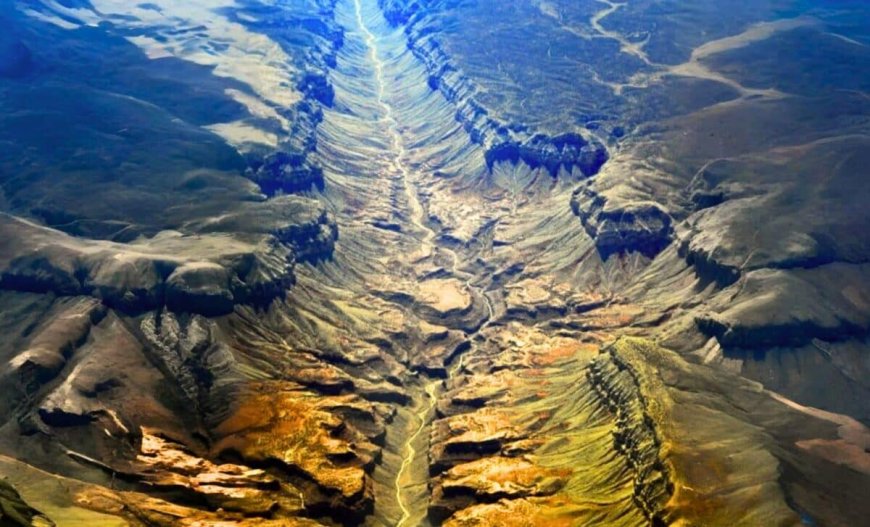
The East African Rift System stretches more than 3,000 kilometers from the Red Sea down to Mozambique. At its core, three tectonic plates (the Nubian, Somali, and Arabian) are separating at a rate of 0.2 to 0.5 inches per year. That pace sounds modest, but over geological time it is enough to reshape entire continents and fill vast valleys with open ocean.
The Arabian Plate has already demonstrated what this process produces. It has been separating from Africa for more than 30 million years, and the Red Sea and Gulf of Aden exist as a direct result. What is now underway between the Nubian and Somali plates is the same mechanism at an earlier stage, and researchers say the evidence is no longer confined to theory.
A 2005 Rupture That Changed How Scientists Read the Rift
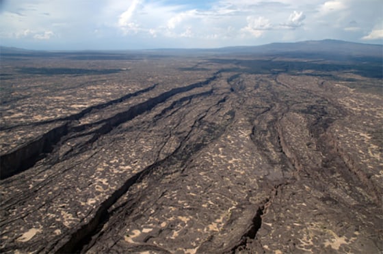
The clearest single event in recent rift history came in 2005, when a 35-mile-long crack tore open across the Ethiopian desert. Scientists confirmed the rupture was caused by tectonic movement and determined it compressed several centuries of normal plate drift into less than two weeks. It was a scale of geological change that had previously existed mostly in historical records rather than direct observation.
Christopher Moore, a doctoral researcher at the University of Leeds, has used satellite radar to track ongoing rifting activity in the region. “This is the only place on Earth where you can study how continental rift becomes an oceanic rift,” Moore said. His instruments are sensitive enough to detect ground movement that would have gone entirely unregistered by earlier survey equipment.
The Afar region of Ethiopia, where temperatures regularly reach 130 degrees Fahrenheit, sits at the center of this activity. It remains one of the most closely monitored geological zones on the planet precisely because it offers something no other location does: a live, observable transition between two fundamentally different types of Earth crust.
Magma, Pressure, and How the Split Actually Works
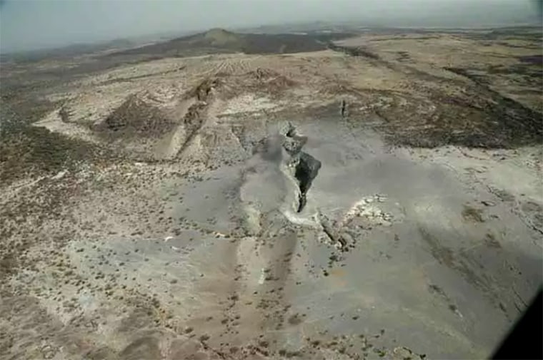
Beneath the surface, a plume of superheated rock is rising from Earth’s mantle, pushing the crustal plates apart and triggering frequent earthquakes and volcanic eruptions. Researchers believe pressure builds gradually in the crust until it releases in sudden bursts, which explains why the rift does not move at a smooth, constant rate. The 2005 rupture was one example of that release pattern.
Geophysicist Cynthia Ebinger, who has conducted extensive fieldwork across the Afar region, described the environment to NBC News as a place that “has been called Dante’s inferno.” Her research has shown that periods of geological calm are regularly followed by sudden tectonic activity, as accumulated magma forces upward through the crust. She has compared the process to an overinflated balloon that eventually bursts.

The rift is distinctive not only for its scale but for what is forming beneath it. Oceanic crust is denser and chemically distinct from continental rock, and it normally exists only under existing oceans. Its presence beneath portions of the East African Rift confirms the region is actively transitioning toward something more closely resembling a seafloor, a process that has not been observed at this stage anywhere else on Earth.
What the Red Sea Has to Do With It
If rifting continues, the Red Sea and Gulf of Aden could eventually pour into the rift valley and create a new ocean basin. That outcome is projected to occur within 5 to 10 million years, based on current plate separation rates. The physical process driving it is measurable today, even if the result lies far beyond any human timescale.
Ken Macdonald, a marine geophysicist and professor emeritus at the University of California, Santa Barbara, explained what is already visible. “As the plates peel apart, material from deep inside Earth moves to the surface and forms oceanic crust at the ridges,” Macdonald told NBC News. “We can see that oceanic crust is starting to form.”
When the split completes, portions of eastern Ethiopia, Kenya, and Tanzania would separate from the rest of the continent, forming a landmass comparable to Madagascar. That separation is not a scenario being modeled in simulations. It is a process that has already begun.
Satellites Are Catching What Previous Tools Missed
For decades, the rift was categorized as slow-moving and stable. That characterization is changing as high-precision GPS and satellite radar allow researchers to detect ground movement at millimeter-scale accuracy. These tools are revealing shifts that were previously too subtle to detect, and they are producing a more dynamic picture of how quickly the geology is evolving.
The same tectonic heat driving the rift is also an energy source. Several East African countries are developing geothermal energy projects that draw on subsurface heat generated by the same forces producing the earthquakes and volcanic activity. The trade-off includes seismic risk, infrastructure vulnerability, and potential displacement in areas where the ground is actively moving.
The U.S. Geological Survey‘s seismic record of the East African Rift from 1900 to 2013 remains one of the most comprehensive long-term datasets on rift activity available. Researchers are combining that historical baseline with current satellite measurements to track how the transition from continental crust to oceanic crust actually unfolds, producing the most detailed account of the process yet assembled.
Enjoyed this article? Subscribe to our free newsletter for engaging stories, exclusive content, and the latest news.
What's Your Reaction?
 Like
0
Like
0
 Dislike
0
Dislike
0
 Love
0
Love
0
 Funny
0
Funny
0
 Angry
0
Angry
0
 Sad
0
Sad
0
 Wow
0
Wow
0