


Seen from space, this South African reservoir glows emerald green and what’s happening beneath the surface tells a very different story
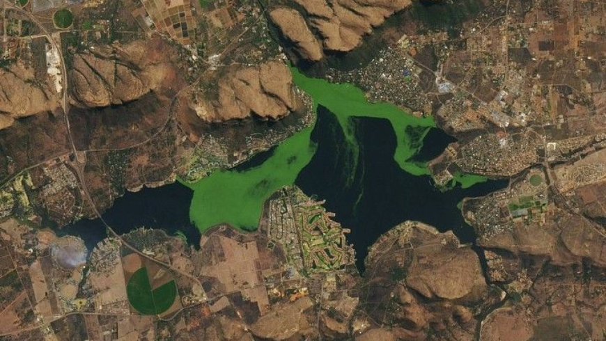
From space, Hartbeespoort Dam looks almost beautiful. A Landsat 8 image captured in August 2022 shows the reservoir near Pretoria draped in vivid emerald, its deep blues interrupted by swirling green masses drifting across the surface.
But that striking color isn’t a sign of a thriving ecosystem. It’s a warning.
The reservoir, nestled just south of the Magaliesberg mountains in South Africa’s North West province, has been producing these blooms for decades — and what they conceal beneath the surface is far more troubling than the spectacle above it.
A reservoir in permanent crisis
Hartbeespoort Dam was built in the 1920s, roughly 40 kilometers west of Pretoria, and has long served a dual purpose: supplying fresh water to nearby cities and farms while offering recreational space for fishing and water sports. On the surface — literally — it can still look inviting. But this isn’t a seasonal rough patch. The reservoir exists in a state of permanent ecological distress.
The technical term is “hypereutrophication” — a chronic overabundance of nutrients, specifically nitrogen and phosphorus. Unlike the seasonal blooms that briefly affect most large bodies of water, the blooms at Hartbeespoort are relentless. NASA’s Earth Observatory notes that satellite images routinely reveal the reservoir’s deep blues interrupted by drifting patches of vivid green. Not a periodic event. The baseline.
The green isn’t only cyanobacteria. The surface mats are a tangled mix of toxic algae and invasive aquatic plants — water hyacinths and Salvinia minima — spreading across the water in dense, intertwined layers that form a living lid over the reservoir.
Dead zones beneath the green surface
What that lid creates below is the real problem. As plant life crowds the surface and blocks sunlight, dissolved oxygen in the water beneath is consumed along with it. The result is what scientists call “dead zones” — stretches of oxygen-depleted water where fish simply cannot survive.
The consequences show up with grim regularity. In April 2023, oxygen depletion was linked to a mass die-off involving hundreds of large carp, according to a government report. In November 2025, another bloom left fish visibly gasping at the surface. These aren’t anomalies — they’re recurring features of a system under sustained stress.
Toxicity compounds everything. Some cyanobacteria species produce chemical toxins that must be actively filtered out before the reservoir’s water is safe to drink. One bloom fades; the next is rarely far behind.
Decades of pollution feeding the bloom
The reservoir has experienced near-continuous hypereutrophication since the 1970s, with one brief interruption: a bioremediation program introduced in the 1990s that showed genuine promise before being scrapped for cost reasons. Since then, the cycle has continued unbroken.
A 2023 study analyzing four decades of data pointed clearly to the Crocodile River as the primary driver. The river, which feeds the dam, carries heavy loads of nutrient-rich runoff from surrounding farms and golf courses — fertilizer draining from fields and fairways into the watershed, delivering exactly the nitrogen and phosphorus that fuel explosive algal growth. A satellite animation compiled from Landsat 8, Landsat 9, and Sentinel imagery between June 2022 and July 2023 makes the cycle visible in stark terms: blooms spreading, dying back, and spreading again in an unbroken loop.
Beyond the water: Risks to people and animals
The damage doesn’t stay in the water. Water-sports enthusiasts who come into contact with the reservoir have reported skin rashes from exposure to the toxic bloom, and dogs that swam in or drank from the water have been sickened by the same cyanobacterial toxins.
The reservoir still supplies drinking water to nearby communities and agricultural operations, requiring constant filtration to remove contaminants that shouldn’t be there in the first place. That treatment burden is ongoing and expensive — a cost borne downstream of decisions made far upstream.
Hartbeespoort is not an isolated case. It reflects a broader global pattern in which agricultural runoff overwhelms freshwater systems, pushing them past the point of natural recovery. Lakes and reservoirs on multiple continents face versions of the same dynamic: too many nutrients, too much growth, not enough oxygen. What makes Hartbeespoort notable is how long it has been this way — and how visible the problem has become, even from orbit.
A reservoir that glows green from space isn’t a curiosity. It’s a record of accumulated choices about land use, water management, and the costs we’re willing to defer. The satellite images already answer whether those choices have consequences.
What's Your Reaction?
 Like
0
Like
0
 Dislike
0
Dislike
0
 Love
0
Love
0
 Funny
0
Funny
0
 Angry
0
Angry
0
 Sad
0
Sad
0
 Wow
0
Wow
0