


Satellite captures Ahe Atoll from orbit, revealing the hidden geometry of French Polynesia’s pearl-farming lagoons
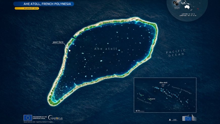
From 800 kilometers above the Pacific, a Sentinel-2 satellite captured something that looks almost too geometric to be natural: a slender coral ring barely clearing the ocean surface, enclosing a lagoon that fades from deep blue at its center to bright turquoise along the shallows.
That ring is Ahe Atoll, one of dozens of low-lying formations scattered across French Polynesia’s Tuamotu Archipelago. What appears from orbit as untouched wilderness is, on closer inspection, a working landscape — and the same satellites now framing its beauty are quietly becoming tools for keeping it productive.
A coral ring in the central Pacific
Ahe Atoll sits within the Tuamotu Archipelago, one of the largest chains of coral atolls on Earth, stretching across a vast expanse of the central Pacific Ocean. The archipelago is a world apart — remote, low-lying, built almost entirely from the accumulated work of coral organisms over millennia.
The atoll takes an elongated form: a narrow ring of reef and small islets enclosing a lagoon of considerable depth. Fragile as it appears, that structure is what makes the place viable — ecologically and economically both.
The Sentinel-2 image makes the geometry legible in a way ground-level observation never could. Shallow reef flats glow bright turquoise along the atoll’s edges, while the lagoon interior deepens to a rich, dark blue. Scattered lighter patches within that blue suggest submerged coral heads or, notably, human-made structures — the quiet signature of an industry operating just below the surface.
Pearl farming in sheltered waters
The Tuamotu Archipelago has a long tradition of lagoon-based pearl cultivation. The calm, enclosed waters of atolls like Ahe provide ideal conditions for oyster farming — protected from open-ocean swells, with water quality that can be carefully observed and managed.
At Ahe specifically, a pearl farm occupies a position along the inner rim of the atoll, where shelter is greatest. This placement is deliberate. Oysters are sensitive to environmental stress, and the still, clear waters of the inner lagoon reduce the variables farmers must contend with.
Pearl farming isn’t a marginal activity here. For many remote communities across French Polynesia, it represents a primary economic pillar — one that depends entirely on the health of the surrounding reef ecosystem. Managing water quality and monitoring oyster health aren’t optional practices. They’re the foundation on which livelihoods rest.
Satellites as stewards of fragile ecosystems
Copernicus Sentinel-2 satellites pass regularly over locations like Ahe, collecting optical imagery that can reveal changes in lagoon water clarity, surface conditions, and reef structure over time. That cadence of observation — consistent, repeatable, wide in coverage — is something no boat-based survey program could replicate at the same scale.
For aquaculture managers, satellite data offers a way to detect shifts in water conditions before they become crises. Changes in turbidity or surface reflectance can signal ecological stress that warrants closer investigation on the ground.
The stakes extend well beyond pearl production. Low-lying coral atolls rank among the ecosystems most exposed to rising seas and warming ocean temperatures. Continuous satellite monitoring provides a long-term record of change, one that supports both ecological resilience and the economic stability of communities with few alternatives if their lagoons degrade.
What the view from space can — and cannot — tell us
Optical satellite imagery has real limitations. Cloud cover can interrupt observation windows, and even in clear conditions, light penetrates only so far into the water column. What lies deeper in the lagoon stays beyond the reach of a sensor looking straight down from orbit.
What satellites do exceptionally well, though, is reveal patterns at scale and track gradual change across time. A single image of Ahe is striking. A time series accumulated over months and years becomes something more useful: a record of how the lagoon is shifting, season by season.
That longitudinal view is increasingly valuable for communities like those on Ahe, where traditional knowledge of the reef now coexists with orbital technology developed on the other side of the world. Pearl farming predates the space age by generations. The practices, the patience, the reading of water and weather — all of it developed without satellites.
Yet here, the two exist in the same frame. A coral ring that formed over thousands of years is now monitored by instruments traveling at 27,000 kilometers per hour, helping to sustain a way of life that neither could protect alone.
What's Your Reaction?
 Like
0
Like
0
 Dislike
0
Dislike
0
 Love
0
Love
0
 Funny
0
Funny
0
 Angry
0
Angry
0
 Sad
0
Sad
0
 Wow
0
Wow
0