


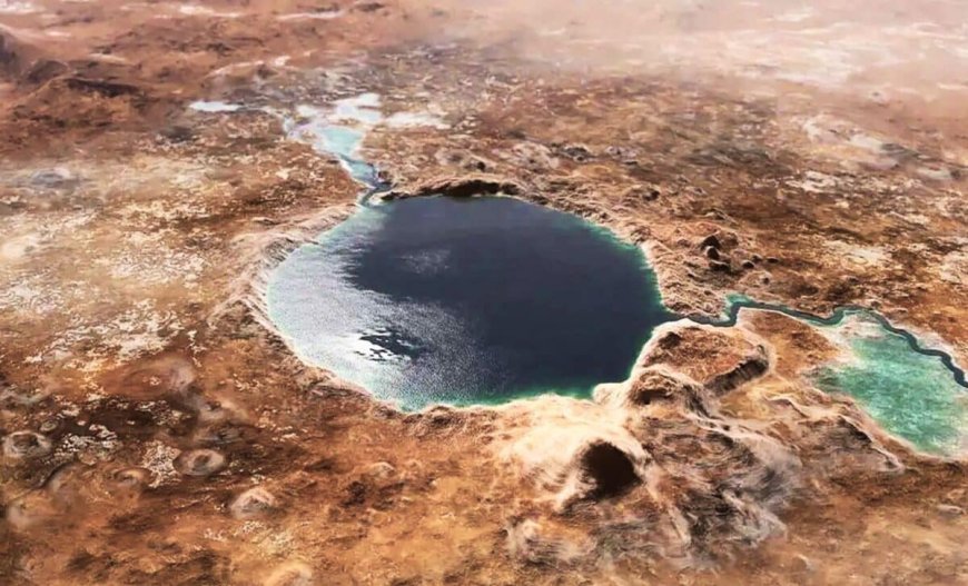
Scientists Uncover Clear Evidence of Liquid Water, Not Just Frozen Ice on Mars
High above the floor of Gale Crater, a series of rhythmic ridges etched into a dark rock layer has upended the established timeline of Martian desiccation. For over a decade, the NASA Mars Science Laboratory mission has climbed the foothills of Mount Sharp, documenting a planetary transition from a watery past to a frozen, arid present. Scientists had long identified the mountain’s sulfate-bearing unit as a geological marker for the era when Mars finally dried out.
However, data transmitted by the Curiosity rover on November 1, 2025, reveals that this supposedly dry period was interrupted by the persistent presence of liquid water. The rover captured high-resolution images of symmetrical wave ripples, textures created by the motion of water waves in a shallow lake billions of years ago. These features represent the most definitive evidence of surface water encountered since the mission began in 2012.
The discovery suggests that the environmental shift on Mars was not a simple, linear decline into aridity. Instead, the climate appears to have fluctuated, allowing for the existence of stable lakes even as the atmosphere thinned and the surface grew increasingly saline. These wave ripples, preserved in a thin layer of unusually hard rock, provide a high-fidelity record of a landscape that remained hydrologically active far longer than previous models predicted.
Geological Evidence from Gale Crater
According to the NASA mission update released in late 2025, the Curiosity rover identified these “ripple marks” at an elevation of approximately 3,700 meters within the Marker Band. This specific layer of sulfate-rich rock proved so resilient that the rover’s robotic drill was unable to extract a sample during attempts on October 27 and October 31, 2025. The hardness of the material is precisely what allowed the delicate textures of ancient water motion to survive billions of years of wind erosion.

Institutional records from the California Institute of Technology (Caltech), which manages the Jet Propulsion Laboratory (JPL), indicate that the ripples are symmetrical. In sedimentology, symmetry distinguishes ripples formed by the back-and-forth oscillation of waves from the asymmetrical ripples created by one-way river currents. This confirms that the Marker Band once sat at the bottom of a standing body of water deep enough to support wind-driven surface waves.
Ashwin Vasavada, Curiosity’s project scientist at JPL, stated in an official mission briefing: “This is the best evidence of water and waves that we’ve seen in the entire mission.” He noted that the team had climbed through thousands of feet of lake deposits without seeing evidence this clear, especially in a region they expected to be dry.
A Volatile Climate Written in Stone
The findings, detailed in a study published in Science Advances, suggest the Martian climate supported complex, recurring hydrological cycles. Beyond the wave ripples, the rover identified “rhythmic” rock layers with consistent spacing. These patterns typically emerge from periodic climate changes, such as seasonal cycles or long-term atmospheric shifts similar to Earth’s Milankovitch cycles.

The NASA Science Mission Directorate has noted that these alternating layers of mudstone and sulfate indicate a landscape that moved between deep lakes, shallow salty pools, and dry dust. Further up the mountain, the rover encountered evidence of high-energy water events in the Gediz Vallis ridge.
This feature contains a pile of boulders and debris that appear to have been washed down the mountain by wet landslides. Because these debris flows occurred later than the formation of the wave ripples, they confirm that liquid water continued to impact the Martian surface in short, violent bursts long after the major lakes had begun to disappear.
Drilling Limits and Chemical Clues
The physical properties of the Marker Band have forced the mission team to adjust their tactical approach for 2026. Because the rock is too hard for the current drill bits to penetrate, the team is relying on the Alpha Particle X-ray Spectrometer (APXS) and the Chemistry and Camera (ChemCam) laser to analyze the exterior surfaces.
Data from these instruments shows that the ripples are high in magnesium and calcium. These minerals often precipitate as water evaporates, suggesting that the lake was becoming increasingly mineral-rich before it finally vanished. The rover also documented “boxwork” patterns—fractures in the rock filled with mineral veins—which indicate that groundwater continued to circulate through the crust after the surface water was gone.
The Martian winter, which began in late 2025, has already reduced the daily energy available from the rover’s radioisotope power source. This constraint requires the mission to balance the pursuit of data from the Marker Band with the need to conserve mechanical integrity.
Charting the Path Forward
The NASA Jet Propulsion Laboratory is currently finalizing the maneuver sequence for the rover to bypass the steepest sections of the Gediz Vallis ridge by April 2026. This path will allow the rover to inspect the debris flows from a closer vantage point to quantify the volume of water involved in those landslide events.
NASA has scheduled a senior review of the mission’s extended objectives for May 2026. This review will determine the funding levels and operational priorities for the rover as it moves toward the “White Hills,” a region where orbital data suggests a shift toward different types of sulfate minerals.
The next scheduled data release through the Planetary Data System is set for March 15, 2026, which will include the full 360-degree Mastcam panoramas of the Marker Band region. The Curiosity rover remains on track to begin its ascent toward the sulfate-to-clay transition zone in June 2026.
Enjoyed this article? Subscribe to our free newsletter for engaging stories, exclusive content, and the latest news.
What's Your Reaction?
 Like
0
Like
0
 Dislike
0
Dislike
0
 Love
0
Love
0
 Funny
0
Funny
0
 Angry
0
Angry
0
 Sad
0
Sad
0
 Wow
0
Wow
0