


Near a California ski resort, a volcanic landscape helps NASA scientists decode eruptions on Mars
Mammoth Mountain is best known for its ski runs, but the terrain surrounding this California resort ranks among the most volcanically complex in North America. Beneath and around it lies a chain of craters, lava domes, and a massive caldera — formed by an eruption that expelled roughly 20 times more material than the largest volcanic blast of the 20th century.
That restless landscape is now drawing a different kind of attention. Alongside geologists monitoring ongoing hazards, planetary scientists are studying the area for what it may reveal about volcanic activity on Mars and beyond.
A chain of craters still taking shape
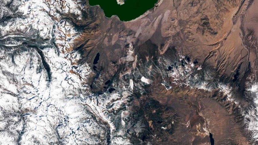
The Mono-Inyo Craters form a string of roughly three dozen lava domes, lava flows, and tephra rings running between Mono Lake and Mammoth Mountain — all less than 10,000 years old and clearly visible in Landsat satellite imagery. This isn’t ancient, buried geology. It’s a chain that has been actively building within human prehistory.
Panum Crater, near Mono Lake, is one of the most recent additions. About 700 years ago, a strombolian eruption deposited a ring of pumice, ash, and obsidian fragments around a central vent. A lava dome then pushed up through the middle, leaving the concentric-circle structure visitors can walk around today.
Mammoth Mountain itself adds another layer of complexity. Built from at least 25 overlapping lava domes, its last magmatic eruption occurred around 57,000 years ago — though that hardly means it’s been quiet. Steam-driven phreatic eruptions and episodes of unrest have taken place far more recently, and scientists continue to watch it closely.
CO₂ vents, dying trees, and a new early-warning approach
In 1989, a magma intrusion beneath Mammoth Mountain triggered seismic activity and began pushing volcanic carbon dioxide to the surface. The gas has since killed trees across several areas around the mountain — a visible, ground-level indicator of what’s happening below. USGS monitors CO₂ emissions there on an ongoing basis.
NASA has contributed a complementary perspective from the air. Researchers used NASA airborne remote-sensing technology to measure how the local ecosystem responded to elevated volcanic CO₂ around Mammoth Mountain. The logic is fairly direct: vegetation stressed by gas emissions changes in ways that instruments can detect before other warning signs appear.
More recent projects have extended that approach to other volcanoes entirely. By incorporating satellite imagery, scientists are working toward systems that could detect vegetation changes as proxies for gas emissions — potentially offering earlier hazard warnings than ground monitoring alone can provide.
The supervolcano beneath the caldera
Whatever the ongoing activity at Mammoth Mountain, it’s modest compared to what happened here 760,000 years ago. A six-day eruption ejected approximately 150 cubic miles of material and collapsed the surface over the magma storage area by thousands of feet, leaving behind the Long Valley Caldera — an oval depression roughly 10 miles wide and 20 miles long.
For scale: that volume is about 20 times the output of the 1912 Novarupta eruption in Alaska, which remains the largest volcanic event recorded on Earth in the 20th century. Long Valley wasn’t an eruption on a familiar scale. It was a landscape-remaking event.
Today, the caldera is bounded by snowy ridges, with Mammoth Mountain sitting just off its southwest rim. Crowley Lake, a reservoir on the Owens River, drains the depression to the southeast — a quiet surface over geology that is anything but ordinary.
From California to Mars: a planetary laboratory
In 2023, scientists with NASA’s Goddard Instrument Field Team conducted research at Long Valley Caldera with a question that extended well beyond California: how might similarly massive eruptions on Mars, and on other planets and moons, have altered those environments over time?
The question isn’t as abstract as it sounds. Mars shows clear evidence of large-scale volcanic activity in its past, and understanding the consequences of caldera-forming eruptions on Earth provides a framework for interpreting what remote sensing reveals elsewhere in the solar system.
What makes the Mammoth Lakes region particularly valuable is that it compresses several distinct types of volcanic activity into one accessible area — active gas venting, recent lava dome construction, a supervolcanic caldera — each of which has analogs on other worlds.
The remote-sensing and satellite techniques being developed here for hazard monitoring may end up serving both purposes at once. Methods refined to detect early signs of unrest around communities on Earth could also become tools for reading volcanic histories written across the surfaces of Mars, the Moon, or the icy moons of the outer solar system.
As satellite capabilities improve and field research accumulates, the Long Valley region is likely to remain a proving ground for both missions. Scientists monitoring the next episode of seismicity or CO₂ flux beneath Mammoth Mountain, and scientists reconstructing the volcanic past of another planet, may find themselves drawing on the same data, the same instruments, and the same unusual stretch of California terrain.
What's Your Reaction?
 Like
0
Like
0
 Dislike
0
Dislike
0
 Love
0
Love
0
 Funny
0
Funny
0
 Angry
0
Angry
0
 Sad
0
Sad
0
 Wow
0
Wow
0