


A Cold War Nuclear Waste Dome Is Cracking Open over a Disaster the U.S. Buried in the Pacific
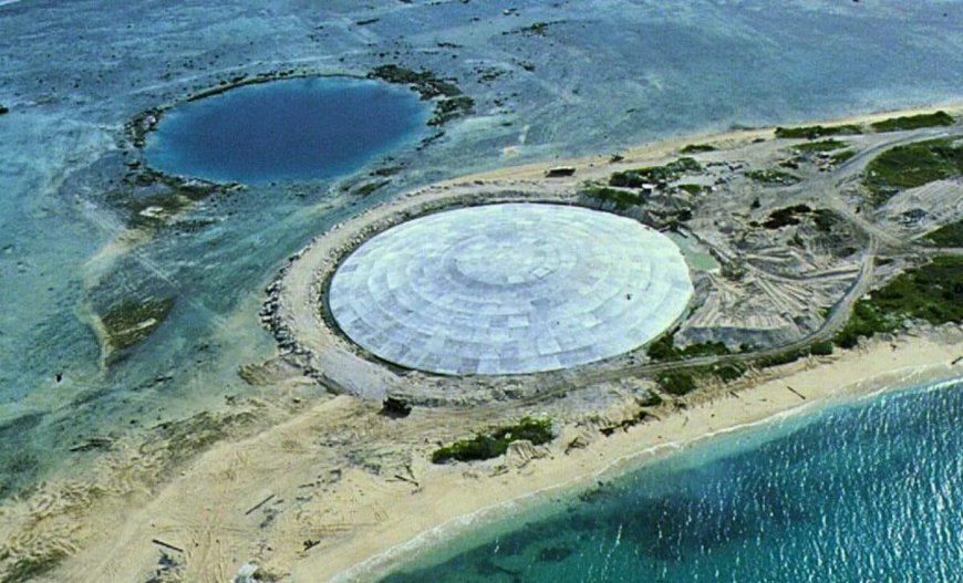
On Runit Island in the Marshall Islands, a concrete lid sits low against the Pacific, close enough to the tide line that the ocean feels like part of the structure. In October 2017, video from the site showed how little land separates the cap from open water. It is the kind of place where you can stand still and hear the lagoon moving behind you.
Nearly five decades earlier, Robert Celestial arrived on Enewetak Atoll as a United States Army truck driver, posted there in 1978 for a mission he said was never fully explained. He remembers draining water from a crater and being told he was dealing with leftover debris from World War II. He did not know the crater had been made by a nuclear blast.
“We were on a small island in the Pacific with 500 guys on it, and it was like Alcatraz. You couldn’t escape,” he said. His orders, he recalled, were simple: move “contaminated” soil to a small island and dump it into a crater. That island was Runit.
The backstory stretches to a concentrated burst of Cold War testing. Sixty-seven nuclear tests were carried out across Enewetak and Bikini Atoll between 1946 and 1958, and more than 300 Marshallese were removed from their homeland to make way for the US program. One detonation, an 18-kiloton device known as Cactus, vaporized part of Runit and pushed a mushroom cloud about 6 kilometers into the sky.
Two decades after Cactus, the crater it left behind, about 10 meters deep, became a dumping ground for more than 120,000 tons of contaminated soil and debris scraped from around the atoll. Celestial said he made countless trips, tipping nuclear debris from the back of his dump truck. When the work ended, the crater was sealed with an 18-inch concrete cap that formed what locals and officials now call the Runit Dome.
A Crater That Became a Tomb
The physical work on Runit was only part of what followed Celestial home. After returning, he said boils began appearing across his body and would bleed through his clothing. He was medically retired after seven years of service, and later reported brittle bone, osteoporosis, arthritis, and kidney and liver issues, while continuing to receive regular injections.
It remains unclear, the report said, whether all his conditions were connected to the nuclear cleanup. The Atomic Heritage Foundation has reported that many veterans suffered cancer and brittle bones after six-month tours on Enewetak. Celestial said it was not until 2023 that the US government officially recognized them as “atomic veterans” who could access disability claims.
He also pointed to the scale of the workforce and how few are left. Of roughly 4,000 troops posted to Enewetak during the 1970s and 80s clean-up, he said only a few hundred were alive today, citing records from the National Association of Atomic Veterans. In his telling, the physical exposure was matched by operational chaos, with dangerous material handled casually.
“We didn’t do a good job,” he said. He added that crews did not always know the plan, and that equipment and “hot stuff” were dumped into the lagoon. That lagoon is still central to daily life on nearby islands, which is why what sits inside the dome continues to resurface as a present-day issue.
What the Concrete Is Starting to Show
Fifty years on, the dome is showing visible deterioration, with cracks lining the outer shell and groundwater flowing beneath the structure. According to ABCNews, that groundwater can move in and out of the dome’s base with the tides, potentially carrying contaminated material back into the surrounding lagoon. Multiple recent studies have cited cracks in the concrete cap, and a United Nations report has pointed out the structure is not watertight.
Ivana Nikolic-Hughes of Columbia University, who is also president of the Nuclear Age Peace Foundation, said she saw the cracks firsthand while measuring radiation levels in 2018. She said elevated radiation levels were found in soil samples outside the dome. With sea levels rising and storms showing signs of intensifying, she said researchers worry the structure’s integrity could be in jeopardy.
She placed the risk in geographic terms, describing Runit as about 20 miles (32.19 km) from where people live and noting that communities use the lagoon. The article cites the 2021 census, saying about 300 people live in Enewetak today, while about 600 people live on Enetewak Atoll. Bikini Atoll, meanwhile, remains too contaminated to inhabit, including Bikini Island, described as the Marshall Islands’ highest lying atoll.
The Argument over What Is Leaking
US authorities have said the dome is not in imminent danger of collapse. The United States Department of Energy said cracks were consistent with aging concrete, and argued the lagoon already contains large amounts of radioactive material from past tests, making any added contamination from the dome small by comparison.
Nikolic-Hughes rejected the logic behind that reassurance. She asked why a dome was built at all if the surrounding lagoon already held far more waste, and said she suspected debris and unexploded bomb material from failed nuclear tests might also be buried inside the structure, though that has never been confirmed. Her concern includes the possibility of concentrated radioactive fragments, rather than diffuse contamination.
That is where the time scales stop matching the engineering. She pointed to Plutonium-239, a radioactive element used in nuclear weapons that remains dangerous for more than 24,000 years. Arjun Makhijani, a nuclear engineer and president of the Institute for Energy and Environmental Research, said no concrete structure could endure even a tiny fraction of that lifespan, noting cracks have appeared in less than 50 years.
A Responsibility Gap in the Rising Tide
The report says the Marshallese government lacks the technical and financial capacity to address the dome, regardless of what is inside it. Under the Compact of Free Association, the country gained independence in 1986 while receiving substantial US funding in exchange for military access. The agreement also settled “all claims, past, present and future” connected to the nuclear testing program, leaving responsibility for the dome largely with the Marshallese government.
Marshallese officials told ABC they did not have the full picture when the compact was signed. A NASA/USGS satellite map included in the story places the dome on the north-east end of Enewetak Atoll, about 30 kilometres from communities that use the lagoon as a food source. The physical distance is short enough that a problem on Runit does not stay on Runit.
Former Marshallese health secretary Jack Niedenthal described the dome as a monument to an American mistake, and said shoring it up has largely meant cement and studies. “So as we get these rising sea levels where everything is only a few feet above the water at high tide, it’s pretty concerning,” he said. The ABC report was posted on Saturday, March 14, 2026, and noted the dome’s cracks are now visible signs on a structure built to outlast a cleanup, not the ocean.
Enjoyed this article? Subscribe to our free newsletter for engaging stories, exclusive content, and the latest news.
What's Your Reaction?
 Like
0
Like
0
 Dislike
0
Dislike
0
 Love
0
Love
0
 Funny
0
Funny
0
 Angry
0
Angry
0
 Sad
0
Sad
0
 Wow
0
Wow
0