


This 1,200-Year-Old City From Alexander the Great’s Empire Has Just Been Found: Here’s What’s Hidden Beneath the Sands
Archaeologists have uncovered the remains of Charax Spasinou, one of thelast cities founded by Alexander the Great, after it had been buried beneath the desert for over 1,200 years. Thanks to drones and advanced imaging tools, the city, once a key trade hub along the Tigris River in present-day Iraq, is now revealing its secrets and shedding new light on Alexander’s legacy and the ancient world.
For centuries, Charax Spasinou was only known through historical records, with its exact location remaining a mystery. But with modern technology, researchers have finally pinpointed where it once stood.
Alexander’s Ambitious Final City
Charax Spasinou was founded by Alexander in 324 BCE, just a few years before his death. Located at the meeting point of the Tigris and Eulaeus rivers, the city was meant to strengthen his empire’s grip on the region. The city was originally called Alexandria, but after floods and military conflicts destroyed much of it, the city was rebuilt and renamed Charax Spasinou in honor of the king who restored it.
Although ancient texts gave researchers an idea of where Charax Spasinou might be, the exact location remained a mystery for centuries. The political instability in Iraq further complicated efforts to locate it, leaving it hidden under the sands for a long time.
How Drones and Magnetometers Found the City
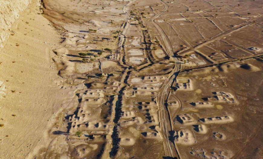
In 2014, archaeologists finally got their chance to explore the area using modern technology. Drones captured thousands of aerial images, while magnetometers were used to scan the ground for buried structures. According to Archeology News :
“Thousands of drone photographs helped build a detailed terrain model. Geophysicists used magnetometers to map buried structures.”
The results were impressive. With the help of these tools, researchers charted the city’s layout, uncovering wide streets, expansive housing sections, temples, workshops with kilns, and a ” district includes house blocks of exceptional size, larger than most known from other cities of the same era”.
This high-tech approach to archaeology has allowed scientists to piece together the city’s design without having to disturb the site physically. The drone images and magnetometer data created a digital map of Charax Spasinou.

A Key Trade Hub in Mesopotamia
Charax Spasinou was a commercial powerhouse. Its location along the Tigris River made it a crucial point on trade routes, connecting Mesopotamia to the wider ancient world. The city’s harbor and proximity to important agricultural and industrial regions would have made it an ideal location for merchants to exchange goods.
“Researchers walked across more than 500 square kilometers and recorded dense scatters of pottery, brick fragments, and industrial debris,” explained the same source.

Enjoyed this article? Subscribe to our free newsletter for engaging stories, exclusive content, and the latest news.
What's Your Reaction?
 Like
0
Like
0
 Dislike
0
Dislike
0
 Love
0
Love
0
 Funny
0
Funny
0
 Angry
0
Angry
0
 Sad
0
Sad
0
 Wow
0
Wow
0