


Archaeologists Finally Cracked the Mystery of the 5,200 ‘Band of Holes’ That Puzzled Experts for Years
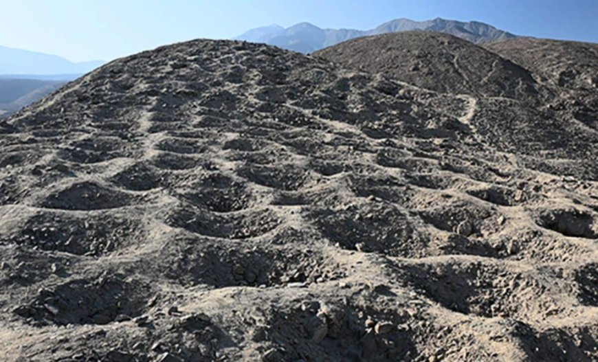
On a barren mountain ridge in the Pisco Valley of Peru, a strange pattern of depressions stretches across the landscape. From the air, the formation looks like a massive, serrated spine carved into the earth. On the ground, it reveals itself as a series of thousands of carefully excavated pits, each roughly a meter wide and nearly a meter deep.
Local residents and archaeologists have known about the site, called Monte Sierpe, for decades. For a long time, the purpose of these excavations remained one of the most persistent mysteries in South American archaeology. Some early observers suggested they were defensive positions, while more imaginative theories once proposed they were graves or even markers for extraterrestrial visitors.

The sheer scale of the site is difficult to process without a wide-angle view. There are approximately 5,200 individual holes arranged in a band that measures about 20 meters wide. This band climbs the steep slope of the mountain for nearly 1.5 kilometers, maintaining a precise, repetitive geometry that suggests a highly organized workforce created it.
Recent research has finally provided a more grounded explanation for why so much effort was poured into this desert hillside. A study led by Charles Stanish of the University of South Florida and Henry Tantaleán of the Universidad Nacional Mayor de San Marcos suggests the site was not a cemetery or a fortress. Instead, it appears to have been a massive open-air accounting tool used by the Inca Empire.
A System for Measuring Tribute
The research team conducted a detailed survey of the site, using drones to map the exact distribution of the pits. They found that the holes are not uniform but are organized into distinct blocks. Each block contains a different number of pits, and the researchers observed that these groupings correlate with the way the Inca managed resources and labor.
During the height of the Incan civilization, which spanned from the early 15th century until the Spanish conquest in 1532, the central government did not use a monetary currency. Instead, they relied on a system of labor and goods known as mit’a. Citizens paid their “taxes” by providing agricultural products, textiles, or physical labor to the state.

The Inca were famous for their use of the quipu, a recording device made of knotted strings. However, a quipu is a portable record, often kept by a single official. The researchers believe Monte Sierpe served as a visible, public version of this accounting system. It allowed the state to measure and verify the amount of tribute being brought into the valley from different regions.
Strategic Location Near the Royal Road
The location of Monte Sierpe is a key piece of the evidence. The site sits directly above a major storage complex and is adjacent to the Camino Real, the royal Incan road. This road was the primary artery for moving goods, troops, and officials across the empire. Anything traveling through the Pisco Valley would have passed within sight of these thousands of pits.
By placing the Band of Holes near these warehouses, the Inca authorities could track the flow of goods in real time. As caravans arrived with supplies, officials could have used the pits to represent specific quantities of grain, cloth, or other materials. Each pit likely acted as a physical placeholder for a set unit of measurement, such as a basket or a bag.

This method of macro-accounting would have been highly effective for a society that managed vast quantities of resources without a written language. It provided a transparent way for different groups to see that their contributions were being recorded accurately. The researchers noted that the pits are located on a slope where they are easily visible from the valley floor, reinforcing their role as a public record.
Organized Labor and Construction
Building more than 5,000 pits into the rocky soil of a mountain was no small feat. The construction required a coordinated effort, which is a hallmark of Incan state engineering. The researchers found evidence that the holes were dug using traditional Incan tools, such as the chakitaklla, a type of foot plow used for breaking hard ground.
Soil analysis and carbon dating of organic remains found near the site confirm that the main period of activity at Monte Sierpe aligns with the Incan occupation of the region. This archaeological precision was made possible through collaborative efforts involving international institutions, including the University of Sydney.

The study also addressed previous theories about the site being a burial ground. While some human remains have been found in the general vicinity of the mountain, the pits themselves were found to be empty of any funerary offerings or skeletal remains. This lack of biological evidence further supports the theory that the site served a logistical rather than a religious or ceremonial purpose.
The Legacy of Incan Administration
The discovery at Monte Sierpe highlights the sophistication of Incan bureaucracy. Managing an empire that stretched nearly 4,000 kilometers along the Andes required more than just military force. It required precise data management and the ability to track the movement of millions of items across diverse climates and terrains.
While the quipu remains the most well-known Incan record-keeping tool, Monte Sierpe suggests that the empire used a variety of methods to maintain order. These earthworks represent a permanent, large-scale solution to the problem of inventory management in a pre-monetary society. They are a physical manifestation of a government’s need to count, verify, and store the wealth of its people.
Today, the Band of Holes remains a prominent feature of the Peruvian landscape, preserved by the arid climate. The site serves as a reminder of the complex social and economic systems that flourished in South America long before the arrival of Europeans.
Enjoyed this article? Subscribe to our free newsletter for engaging stories, exclusive content, and the latest news.
What's Your Reaction?
 Like
0
Like
0
 Dislike
0
Dislike
0
 Love
0
Love
0
 Funny
0
Funny
0
 Angry
0
Angry
0
 Sad
0
Sad
0
 Wow
0
Wow
0